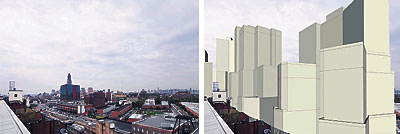
Here’s what the area around Bruce Ratner’s Atlantic Yards mega-development will look like if the 16-tower, arena, residential, office and hotel complex is built, according to new renderings created by a Brooklyn photographer.
“I was bothered by the fact that Ratner’s renderings make the impact look less because the photos were from so far away,” said the photographer, Jonathan Barkey, a Brooklyn Heights resident.
“But when you show his plans in the proper context, you see how colossal it is.”
In one series of before-and-after shots, a wall of Ratner buildings completely blocks views of the Williamsburgh Savings Bank tower.
In another, a quiet Dean Street playground becomes overshadowed by five buildings.
Barkey said all his photo illustrations were compiled using the density and bulk figures in the state’s draft environmental impact statement.
“How big are his buildings? They’re roughly the size of the buildings you see when you look across the river at Lower Manhattan,” he said.
“It’s almost science fiction that they would put something like this in the middle of a garden district like Prospect Heights.”
Spokespeople for Ratner would not comment on the validity of Barkey’s renderings, but Daniel Goldstein, spokesman for Develop Don’t Destroy Brooklyn, had one word when he saw them: “Wow.”
In a statement, Goldstein went further: “In the DEIS, Ratner and the state of New York say that the project would not change the neighborhood character … See the renderings and draw your own unbiased conclusions.”
The complete set of Barkey’s illustrations can be viewed at http://www.pbase.com/atlanticyards/simulation/.