City greenspace gurus recently released plans to improve and expand the Brooklyn Waterfront Greenway — much to the delight of Kings County cyclists. Now, the only thing standing in the way of the scheme’s implementation are the borough’s community boards, from which the Department of Transportation and Parks Department are currently seeking advisory approval.
“I’m cautiously optimistic that this will get done,” said Brian Hedden, co-founder of Bike South Brooklyn, a bicyclist advocacy group mostly focused on the southern half of the borough. “There’s no telling when the Parks Department or Department of Transportation would actually go to the community board with any of this.”
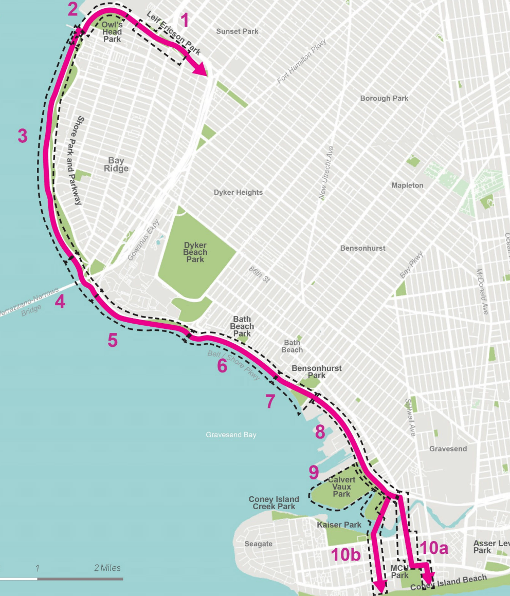
The Brooklyn Waterfront Greenway — set to span southern Brooklyn from Leif Erikson Park in Bay Ridge to Six Diamonds Park in Coney Island — came to be after years of advocacy from Brooklyn bike enthusiasts, who in 2012 got city transportation officials to pledge the constructing a 26-mile cohesive bike lane, which ten years later still hasn’t been fully realized.
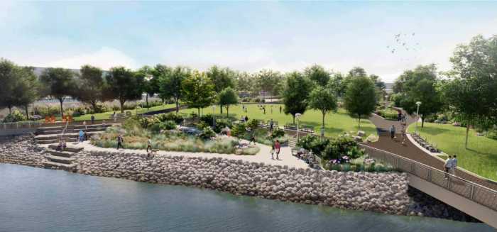
The newest phase of the project — dubbed Destination Greenways — would bring a suite of new improvements to the still-under construction bike network, including the creation of additional seating, widening of existing bike lanes, and introduction of new street connections. The project’s goal, according to both Parks and DOT, is to enhance public space for pedestrians, cyclists and, in some southern-most areas, even fishers.
“For the sections of the greenway they’re talking about upgrading, [the Parks Department] definitely looking at it with all the users of the greenway in mind,” Hedden said. “There is some emphasis on reducing the conflicts between people biking and people walking, and there’s also some emphasis on the people using the waterfront itself in terms of the fishing amenities, eliminating the conflicts between people fishing and other users of the greenway. Right now all that takes place in a very small amount of space.”
In fall of 2020, the Parks Department announced that it would launch Destination Greenways to improve two greenways n Brooklyn and Queens. The next month, the agency began hosting workshops to field ideas from local cyclists, and the greater community in both boroughs. Parks completed its conceptual plan for the greenways this winter, and presented their plans to Brooklynites on Feb. 15.
Southern Brooklyn cyclists in attendance at the first community meeting in November 2020 were adamant that the project extend it scope to include a 3.5 mile gap between Six Diamonds Park in Coney Island and Brigham Street in Sheepshead Bay.
Although they don’t get the additional 3.5 miles of bike lane in the current scheme, Hedden told Brooklyn Paper he and other cyclists are feeling positive about the other proposed improvements.
“The plan seems to look pretty good. It would be a great upgrade to have for the Brooklyn Waterfront Greenway [on Cropsey Avenue],” Hedden said.”Especially having the connection to Coney Island for the first time with the very important addition.”
Transportation representatives outlined additions that would be introduced on each section of the boardwalk and the cost for improving each area at the Feb. 15 “Community report-back meeting.”
The project with the highest price tag is the improvements from a dedicated greenway bridge connecting bicyclists and pedestrians from Six Diamond Park to W. 23rd Street on the Coney Island Peninsula, and will also include a slew of other improvements such as a new route through the park, seating plazas on the bridge, new and improved on-street bicycle connections to the Coney Island Boardwalk, bike racks, a bike repair station, as well as new lighting and signage.
Prior to the construction of the bridge over Coney Island Creek, the Parks Department will construct a makeshift on-street connection to Coney Island using Cropsey Avenue from Bay 52nd and 53rd Streets to W. 19th Street or from W. 15th Street.
Another part of the project racking up four dollar signs is the full-scale street reconstruction of Shore Parkway from Bat Parkway to Cropsey Avenue. Via this initiative, the city’s Department of Transportation and Department of Design will introduce a green stormwater management to the area, which will also see a widening of the bike lane, new tree plantings and improved signage.
Bicyclists would have the option to loop through Calvert Vaux Park in Gravesend, where the proposal plans to construct an accessible path through the green space’s native plantings. If the plan is passed, other improvements to the park include a boardwalk over the seasonal wet area, a pollinator garden, a viewfinder to birdwatch, additional seating, lighting and signage.
While nearly all of the 11 projects bring improved signage and lighting, new seating and widened bike lanes, some of the notable improvement for the seven other projects include:
- Lief Erickson Park will see the addition of a new in-park greenway segments from Second Avenue and RIdge Boulevard to Fourth Avenue; and from Second Avenue to Fifth Avenue, bicyclists and pedestrians will see enhanced street crossings.
- Between Owl’s Head Park to Narrows Botanical Gardens, the Parks Department will add a new on-street connection, improved habitat and biodiverse plantings, a new comfort station and bike racks.
- Improvements between American Veterans Memorial Pier and the Verrazzano-Narrows Bridge will include plantings along parkway buffers, amenity strip plantings, bicycle wheel channels on pedestrian bridge steps, viewfinder, bicycle repair, a fishing spot and a drinking fountain with a bottle filler.
- Down under the Verrazzano Bridge, the proposal includes a vehicular and bicycle ramp to Fourth Avenue, a separate accessible pedestrian ramp to Fourth Avenue, stepped seating on planted hillside, bike racks, drinking fountain with bottle filler and a fishing spot.
- The agency will enhance the greenway section between the Verrazzano-Narrows Bridge and Dyker Beach Park with plantings along parkway buffers, seating and planting along promenade, a separate secondary shared path, paths through native plantings, sloping lawn to buffer parkway, a pollinator garden, a viewfinder and a drinking fountain with a bottle filler.
- Dyker Beach to Bensonhurst Park will also see plantings along parkway buffers, amenity strip plantings, pedestrian bridge landing plantings, bicycle wheel channels on pedestrian bridge steps, a fishing spot and a viewfinder.
- At Bensonhurst Park, the agency proposes seating and planting along promenade, an improved entrance, seating and planting along Bay Parkway, a fitness station, a picnic area, drinking fountain with bottle filler, bicycle repair and a viewfinder.
The projects await approval from community boards 10, 11 and 13 for their advisory approvals, before acquiring funding for the 11 projects which are at the lowest $1 million, and at most $20 million.
Though, Hedden describes his attitude that the projects will move forward as presented as “cautiously optimistic,” he looks forward to seeing a more pro-bike attitude on the borough’s community board with the help of newly-elected Brooklyn Borough President Antonio Reynoso, who himself is a bicycle enthusiast, and whose post approves community members to the advisory board.
While Community Board 11 has yet to receive the conceptual plans for the project, it’s District Manager Marnee Elias–Pavia told Brooklyn Paper she found them on the website, in addition to attending the recent meeting on the project, and there hasn’t been a meeting scheduled on the project yet.
Therefore speaking from her own personal opinions, she said the improvements will be a “welcomed investment into the community,” but was surprised to see that resiliency measures weren’t included in the Bay 8th Street to Bay Parkway section of the greenway, which she said is prone to flooding whether from stormwater, high waves, or saltwater wash over.
“I was surprised that the presentation did not include resiliency measures for the Bay 8th Street to Bay Parkway segment,” Elias- Pavia said. “This segment experiences flooding from stormwater, wave action, and saltwater wash over and resiliency measures should be included in any project proposed for the waterfront.”
Community Board 10’s district manager Josephine Beckmann said that since the plans are conceptual, the board has not received them from the agency yet, but there were board members in attendance. The project has not undergone a full review by the board spanning Dyker Heights, Bay Ridge and Fort Hamilton.
“We did have board members in attendance they viewed the conceptual plan, it has not been reviewed as a community board because it’s still conceptual,” Beckmann said. “Certainly, the Shore Road Promenade area and future visions of this greenway are important to us and we will have an informed discussion about this proposal.”
Representatives for Borough President Antonio Reynoso and Community Board 13 did not respond to requests for comment by press time.