Could Coney Island Creek become the Great Barrier Creek?
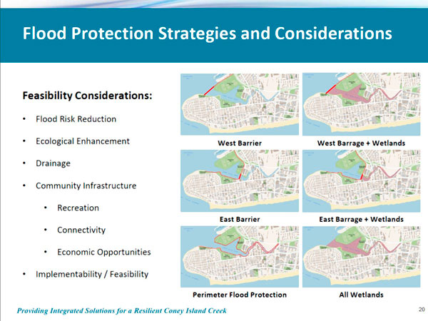
A Coney Island Creek tidal barrier at W. 23rd Street, connecting Coney Island with Gravesend’s Six Diamonds baseball field, is the most viable option for protection from another Superstorm Sandy-like event, according to the city’s economic development agency.
Representatives from the city’s Economic Development Corporation discussed findings from an in-progress resiliency study with Community Board 13 on July 21. The team presented a variety of strategies for preventing future flooding, but said a barrier at the Creek’s eastern end promised the greatest benefits, both environmentally and economically.
“The Eastern Barrier is more financially feasible and has less of an ecological impact, allowing for the more pristine part of the creek to not be impacted,” said Elijah Hutchinson, the agency’s assistant vice president for resiliency.
One of the flood resiliency initiatives proposed in the June 2013 study, “A Stronger More Resilient New York,” called for a 1,700-foot-long tidal barrier and wetlands project further west at the mouth of the creek, by Bayview Avenue and W. 35th Street, but the 500-foot eastern barrier proposed last week is less than one-third that size.
The idea of a barrier conjured up images of a wall in the minds of some of the board’s members, but Hutchinson said the barrier would only be completely closed major storms.
“This does not have to be a wall. It could remain open to allow for tidal flushing to go back and forth,” he said, “and in anticipation of a storm those gates would be closed.”
The proposal also calls for pedestrian and bike paths across the barrier connecting Coney Island to the ballfields in Gravesend, but Hutchinson said that any recreational aspects of the study would not detract from the main goal: flood protection.
“We don’t want to lose sight of the flood protection objective,” he said, “but we have heard very strongly from people about the possibilities for a connection between Coney Island and Gravesend.”
But one local environmental activist suspected that the economic development agency is pushing the “Eastern Barrier” plan for its own reasons.
“It’s one thing if you’re talking about flood protection, but there are so many hidden agendas at work here that I’ve lost count,” said Ida Sanoff. “Every pie-in-the-sky project that has languished on the back burner for years is being resurrected in this flood control project.”
Sanoff said she believes the agency is pushing the alternative to the more extensive wetlands project proposed in 2013 because a barrier at W. 35th Street would interfere with its plan to bring a ferry stop to Coney Island.
Results from the study will be handed over to the Army Corps of Engineers — the agency responsible for constructing whatever structure is chosen — when the study is completed by the end of the year. The Army Corps is currently conducting a similar study for Sheepshead Bay, Jamaica Bay, and the Rockaways.