Talk about buried treasure!
For years, the Brooklyn Historical Society had no idea that it was sitting on an incredibly rare map of New York City dating back to the mid-1700s, until workers literally unraveled it.
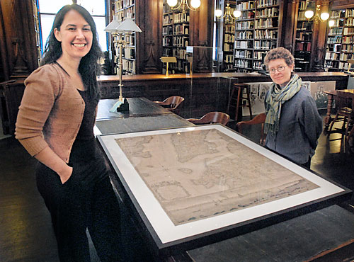
Much of the society’s collection has been in storage since the renovation of the Brooklyn Heights building ended in 2003. But when the Society’s map expert was cataloguing items last May, she came across an especially decrepit one, discolored to a nice burnt orange and brittle to the touch.
Once unrolled, it was revealed to be a map of New York City dating to around 1770, one of only four in existence made by cartographer Bernard Ratzer. Thanks to an inscription on the back, the society surmised that it was a gift from the once-prominent Pierrepont family.
It is not uncommon for a historical society, especially one that’s close to 150 years old, to misplace items sometimes, said Society President Deborah Schwartz.
“We have very sophisticated cataloguing procedures at this point in time, but they didn’t exist previously,” said Schwartz.
In fact, people who study this kind of thing didn’t even know that there was a fourth Ratzer map. Other editions are currently housed at the New-York Historical Society, which has two, and the British Library in London.
The map in question shows parts of Lower Manhattan, Governors Island, New Jersey, and northern Brooklyn, or “Brookland,” which was mostly patches of farmland at the time. Thanks to the very extensive survey of the land at that time, the map provides a level of detail not often found on maps from this period, said Carolyn Hansen, the Society’s map cataloguer.

“To my knowledge, it is the most complete cartographic portrait of New York City from the 18th century,” she said. “After researching the map, I felt both excited and concerned. One the one hand, it is a tremendous joy to find such a rare piece. On the other hand, the map was in terrible condition and would need extensive conservation in order to be saved.”
So, they called in an expert: Jon Derow. The Park Slope-based conservator deals in all matters of aged paper, and had worked with the society previously restoring another prized possession of the society — a diary of Dutch settler Jasper Danckaerts from 1679.
Derow also was a bit daunted by the challenge posed by the nearly 250-year-old map.
“It was somewhat shocking, the condition it was in,” said Derow. “It was severely deteriorated, and extremely brittle. I was concerned that any handling at all would just fracture it into many pieces, and I wouldn’t be able to reassemble it into anything resembling a map.”
Despite the initial concerns, with a little patience and a steady hand, Derow was able to work his magic. After several weeks of treatment, which included washing the map to deacidify it and restore the color, as well as disguise damage due to cracks, he was able to repair the map to its original condition. Well, almost.
“It’s not in as good condition as when it was first made, but it will last hundreds of years,” said Derow.
For now, the map is available at the Brooklyn Historical Society for research purposes, but it will be put on permanent display in about a year once work on its gallery is completed. Then, history buffs can admire this long-lost piece of history.
“It’s breathtaking, it’s a beautiful map,” said Schwartz. “And now, it’s in unbelievably fantastic condition.”