Proving that a picture is truly worth a thousand words, a community activist
and longtime supporter of the plan to build a Brooklyn Bridge Park set
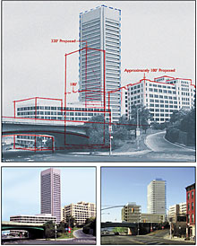
off a flurry of anxious e-mails this week when he distributed a computer-generated
image of what he believes a planned 30-story condominium tower at the
park’s southern end would look like.
Roy Sloane, a member of the Cobble Hill Association who owns a small advertising
agency and specializes in graphic design, circulated an e-mail with an
image he created depicting how the park would appear from a western-facing
view at Atlantic Avenue.
“My goal was to get an accurate picture out there and have an open
discussion,” said Sloane, who opposes plans by the park’s state-appointed
development corporation to finance the annual $15.2 million operating
budget by building five luxury residential buildings.
Unlike most parks in the city, Brooklyn Bridge Park, which is planned
for the waterfront roughly between the Manhattan Bridge overpass and Atlantic
Avenue, is mandated to be self-sufficient, paying for its own costly maintenance.
The city and state have agreed to finance the estimated $150 million it
will cost to develop the open space, commercial and housing development.
Since the plans for the housing were introduced to media and select community
groups late last year, subsequent meetings held by the Brooklyn Bridge
Park Development Corporation (BBPDC) and its lead designer, the landscape
architecture firm Michael Van Valkenburgh Associates (MVVA), have shown
attendees various renderings of what the park would look like from a multitude
of viewpoints as well as a model.
None of the images showed proposed luxury high-rise residential buildings
near Pier 6 and Atlantic Avenue inside the park, said Sloane. One of the
towers will rise to 30 stories.
Though a two-building hotel and a restaurant are planned for the park
at Old Fulton and Furman streets, and a 16-story residence is planned
at John and Adams streets in DUMBO, residents near the southern end of
the planned park have complained about getting the brunt of the new high-rise
development.
“We are paying a price, and it’s important for people to know
what that price is,” said Sloane.
On July 13, he e-mailed a rendering he made of what he imagined the proposed
park’s entrance to look like — a skyscraper towering above the
Brooklyn-Queens Expressway overpass and neighboring former Watchtower
plant at 360 Furman St. — to 51 recipients, including members of
the state-mandated Community Advisory Committee to the BBPDC, the development
corporation and the designers.
“My purpose is to help the public visualize how the southern entrance
of Brooklyn Bridge Park will look,” Sloane said, and in the e-mail
accused the BBPDC of not including “ANY renderings or images of the
proposed buildings of the Atlantic Avenue entrance.”
Three architects familiar with the plans were consulted on the image,
he said.
Sloane’s rendering was lambasted and called inaccurate in a response
e-mailed the next day by the BBPDC’s executive director.
“The drawing is incorrect about the proposed building location and
height,” wrote Wendy Leventer, in a response sent to the same distribution
list Sloane had used, as well as to elected officials and members of the
press.
“We would also like to correct the statement that, ‘The BBPDC
has not been forthcoming with information or details regarding the buildings’,”
to which she cited “three occasions where views along Atlantic Avenue
have been discussed in public meetings.”
An original rendering of the Pier 6 high-rise, which Leventer claimed
had been released to the public and community groups in meetings, was
attached to the e-mail.
The meetings she cited, from January and February, were held in Van Valkenbergh’s
offices in Manhattan, expressly for the members of the Community Advisory
Committee. The meetings were publicized by invitation only, and came before
a Feb. 22 open public meeting in Downtown Brooklyn.
Van Valkenbergh had a similar reaction, saying Sloane’s image was
misleading, and providing what he called a “to-scale” version.
“Renderings put forth by certain members of the community do not
accurately portray the actual development at Pier 6, which is needed to
help define and fund the park. In fact, they distort the development,”
wrote Lee Silberstein, a spokesman for Van Valkenburgh, in an e-mail to
The Brooklyn Papers.
“A visual presentation and design concept for the project have been
repeatedly shown to the community,” he wrote.
Silberstein added that the image sent out by the BBPDC in response to
Sloane’s e-mail was first shown as part of a Power Point presentation
at a community meeting on April 16 at Long Island College Hospital.
Sloane said the image has not widely enough been made public. “We
don’t have anybody that recalls seeing it,” he said, referring
to the CAC.
As of press time, the BBPDC Web site did not contain the rendering.
Silberstein added, “There’s no better way for people to see
what the proposed development is going to be than to take a look at the
model. Any rendering is going to be from an artist’s perspective
and is open to interpretation.”
Sloane used a different terminology.
“They cheated it,” he said of the BBPDC rendering. “It’s
not from the pedestrian’s viewpoint, it’s back further from
the street.
“That’s why they didn’t play it up,” said Sloane.
“It wasn’t distributed, it wasn’t widely circulated, it
wasn’t up on the Web site and it wasn’t released to the press.”
About 50 community members met in the muggy, sweltering heat at Fulton Most of the attendees were members of the Community Advisory Council to Standing on various pylons, bollards and stairs to project his voice over At Pier 1, he stopped to explain how the two-building hotel and adjacent Sandy Balboza, president of the Atlantic Avenue Betterment Association “I think [the pictures] will show people visually what everybody’s “But I think the tour last night really said it all,” she told “What came out of Matt [Urbanski’s] mouth — that they want “I don’t know the difference between separating and privatizing. Sloane agreed.
“I want to see the debate be about the entrance, not about the merits
Tour of piers
Ferry Landing Tuesday night to take a walking tour of the piers slated
for Brooklyn Bridge Park development and get the first up-close look at
the East River site, guided by Matthew Urbanski, a principal of Michael
Van Valkenburgh Associates.
the development corporation, who had been notified by e-mail of the gathering.
the roar of Furman Street traffic and boats jetting across the harbor,
Urbanski gestured to where new landscaping, plantings, plaza areas, access
roads and buildings would be situated for the new park.
residential suites would be separated from Furman Street and the park
by being an “island unto itself” surrounded by a street on either
side.
and a CAC member, thought Sloane’s images helped her visualize the
impact of the building design, but the walk-through presentation spoke
more to her, she said, than renderings or models.
talking about, how the housing is going to dominate the entrances,”
she said.
The Papers.
to separate the park from the housing — in other words separate the
public part of the park from the private part of the park, says the housing
is inside the park,” she said. “It’s always going to create
a tension between the private condos and the public space.”
To me if you’re separating, you’re privatizing.”
of the various drawings,” pointing out that both drawings proved
the point to him: “It doesn’t look like a park, it looks like
a housing development.”