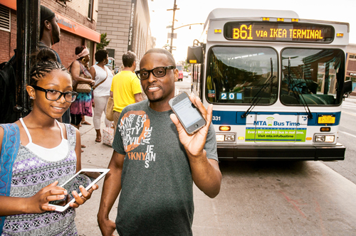
Tech-savvy riders of the B61 bus can track the whereabouts of the sometimes-flaky transit line as it runs its Downtown-to-Windsor Terrace route thanks to a satellite-guided system launched by the Metropolitan Transportation Authority last Sunday.
The program lets commuters check smartphones and computers to learn the exact location of the bus at any moment, helping them gauge if they need to hoof it to the nearest stop as fast as possible — or if there’s enough time to grab a breakfast sandwich on the way.
Riders hailed the system as a useful and necessary improvement, especially after a report last year showed B61 busses often arrive too late or not at all.
“It’s a great addition,” said rider Brian McCormick. “As long as you know what to expect, then you can plan.”
Fewer than half the busses on the line — which serves the transportation-starved communities of Red Hook and the Columbia Waterfront District — come on time during morning and evening rush hours and many are packed full, according to a survey put together by Councilman Brad Lander (D–Park Slope) and dozens of volunteers.
But unlike the B61 itself, the app worked perfectly when our crackerjack intern tested the technology on Monday.
Users can now download the app at bustime.mta.info and riders who don’t own smartphones can receive text message updates.
That pleases Lander, who said it’s a good step to improve the bus line.
“The B61 has been erratic [so] it’s all the more important for riders to know if it will be there when they need it,” he said.
He said he’s also pushing for more busses during peak hours and countdown clocks at stops.
A spokeswoman for the MTA said the service costs about $7,200 per bus — or roughly $180,000 for the whole line, far less than the B63’s $500,000 bus-tracking program.
Riders are jumping on board.
“It’s useful and a lot more convenient,” said straphanger Fitzie Piarson.
— With Alfred Ng
Reach reporter Natalie O'Neill at noneill@cnglocal.com or by calling her at (718) 260-4505.


