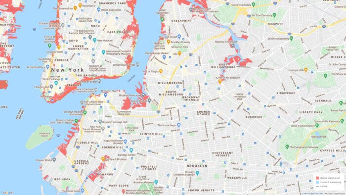
Miles of low-lying neighborhoods along Brooklyn’s coast will suffer annual floods by 2050 because of rising sea levels, scientists predict in a new interactive map.
Stretches of Coney Island, Brighton Beach, Gravesend, Gowanus, Red Hook, Marine Park, Canarsie, and all of northern Brooklyn’s coastline will be flooded at least once a year as storm surges and hurricanes become more frequent because of global warming, the map shows.
The map — which was released by Climate Central on Dec. 1 as part of a study published in the science journal Environmental Research Letters — allows users to adjust the year, the amount of luck, and pessimism of the source material to view a range of sea level predictions from 2030 to 2100.
Some of the worst flooding is projected to take place in Greenpoint along McGuiness Boulevard and on Greenpoint Avenue down to Newel Street, as well as on the streets within one block of the waterfront. East Williamsburg’s waterfront around the edge of Newtown Creek will also be badly hit, as will the Brooklyn Navy Yard and the blocks along the Gowanus Canal, according to the study.
In southern Brooklyn, Coney Island and Brighton Beach will see the most flooding on Neptune Avenue between W. 31st and W. 19th streets and on Shore Boulevard between West End Avenue and Oxford Street.
Water will also consume the edges of Floyd Bennett Field, the southern-most points of Bergen Beach, and southern Canarsie, according to the map, which pulls its data from a “highly-cited” 2014 sea level projection study.
The map’s debut comes the same day its authors published a study about the number of affordable housing units threatened by rising sea levels nationwide, The Verge reported. In that study, New York City is listed as having the most affordable housing units threatened by rising sea levels in the country, with 4,774 units predicted to be in a flood zone by 2050.
That number, however, encompasses only 1.3 percent of the city affordable housing stock, making the system less vulnerable on the whole than affordable housing networks in other coastal areas. And hopefully, city government will establish other protections for affordable housing in the meantime, the study adds.
“Rich cities like New York generally have more resources to bolster protection than poorer ones,” the report reads. “For example, New York City not only plans to increase its supply of affordable housing by 50-percent in 10 years, but has also revised its building design guidelines to address the projected impacts of climate change.”
But the future still remains bleak for the borough’s sea level rise. Even in a “lucky” scenario — in which global warming has a weaker effect on sea levels than scientists predict — large portions of Brooklyn’s coast remain at risk.
The city has already begun implementing measures to incentivize homeowners to build storm-resistant infrastructure and to reduce construction on floodplains. In a new proposal known as the Zoning for Coastal Flood Resiliency plan put forward by the Department of City Planning, homeowners in floodplains would have more leniency to retrofit their homes without adhering to strict zoning codes, and nursing homes would be barred from opening in the most at-risk flood zones.
“We want to expand the relief so that homeowners are not as frequently faced with the challenge of ‘should I lose livable space in order to make my home resilient?’” said Catie Ferrara Iannitto, a resiliency planner with the department.
See if you’re in a floodplain by checking out the interactive map here.